

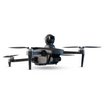
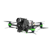
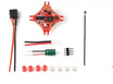


In today's fast-paced world, where safety and security are paramount concerns for organizations, regions, and communities alike, the role of surveillance has become increasingly vital. With advancements in technology, aerial surveillance has emerged as a game-changer, offering unparalleled capabilities in monitoring, analyzing, and securing diverse environments. Technology is advancing, and aerial surveillance is becoming increasingly important in the struggle for public safety. Imagine eyes in the sky, actively examining and safeguarding huge, varied landscapes rather than merely seeing them. Elevate, a pioneering drone by insideFPV, is one of these airborne patrols; its features completely rewrite the norms of surveillance.
Imagine this marvel on patrol across busy cityscapes, spotting suspicious conduct before it happens because of its precise vision. Imagine it swooping over large farmlands, detecting irrigation leaks or keeping an unmatched level of precision track on crop health.
- Enhancing Safety and Security:
The increasing demand for safety and security across diverse sectors has pushed aerial surveillance to the major spotlight. Drones, with their unique mobility and perspective, offer invaluable support in various applications, including traffic monitoring, border patrol, and search and rescue in case of public safety in any country. Drones are playing an increasingly important role in enhancing security due to their aerial capabilities, affordability, and AI integration. Drones provide a bird's-eye view that enables real-time monitoring and surveillance over large areas at relatively low costs compared to traditional manned aircraft or satellite imagery.
Police and law enforcement agencies are using drones for better crime scene analysis, suspect pursuit, and crowd monitoring. Drones can provide critical visual data to assist officers on the ground for coordination during raids, protests, or emergency situations. Their thermal imaging cameras also help in search and rescue missions. Drones equipped with night vision support round-the-clock patrolling and perimeter security checks for prisons and border areas.
Critical infrastructure facilities like power plants, ports, and pipelines are securing their premises with drone surveillance to detect threats and unauthorized activities early. Drones can autonomously conduct inspection of vast industrial facilities to check for risks like gas leaks or structural damages. Equipped with radiation sensors, they also aid in monitoring nuclear sites against safety breaches.
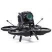
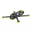
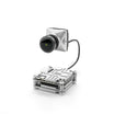
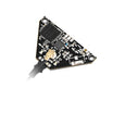
Elevate, a pioneering drone by InsideFPV, distinguishes itself through its commitment to both safety and efficacy. Its 4-way obstacle avoidance system and precision home return functionalities ensure seamless navigation, minimizing risks during missions. Its 4K resolution and low-light camera capabilities make it indispensable for night patrols and surveillance in challenging environments. By effectively combining safety features with advanced monitoring capabilities, Elevate elevates the potential of aerial surveillance, contributing to a more secure and efficient world.
https://insidefpv.com/products/elevate
- Consumer Applications:
Drones are increasingly being adopted by consumers for aerial surveillance in a variety of useful ways.
Drones have made it possible for hobbyists to take photographs and videos from unusual angles that were previously unattainable. Wildlife conservationists can now follow animals responsibly and check national parks without disturbing poachers thanks to drone technology.
Drones are very useful to small enterprises, particularly in the agricultural and infrastructure inspection industries. Usage of Camera-drones to examine damage at infrastructures to examine infrastructurally challenging damages at a low cost. Drones reduce expenses by precisely pinpointing problem areas and enabling focused response.
Elevate user-friendly interface and mobile-operated functionality make it accessible to enthusiasts of all levels. From capturing breathtaking aerial footage of vacations to filming outdoor activities, Elevate empowers travelers to immortalize their experiences from unique perspectives. Its 1080p live view and 4K resolution capabilities elevate content creation to new heights, enabling individuals to relive their adventures with unparalleled clarity.
- Agricultural Advancements:
In the realm of agriculture, aerial surveillance holds immense potential for optimizing crop management and yield. Farmers use drones to take hyperspectral images to track crop development and identify infections early. Drones equipped with sophisticated sensors can monitor crop health, detect pests, and assess irrigation needs with precision. Elevate's extended battery life and expansive SD card capacity enable uninterrupted aerial monitoring, facilitating comprehensive crop surveys. By leveraging Elevate's smart modes such as gesture photography and motion sensor technology, farmers can streamline data collection processes and make informed decisions to maximize agricultural productivity. It can help in maintaining surveillance for wildlife
- Defense and Homeland Security:
Aerial surveillance is integral to safeguarding national interests and maintaining vigilance against potential threats. Military and law enforcement agencies utilize drones for reconnaissance missions, border patrols, and counter-terrorism operations. Elevate's versatility and maneuverability make it an ideal asset for surveillance in diverse terrains and scenarios. With its advanced features like headless mode and gesture photography, Elevate enhances operational efficiency, enabling swift and precise intelligence gathering for defense and homeland security purposes. Coast guard units can use drones to augment the surveillance of illegal fishing, smuggling, piracy, or terrorist activities across vast, hard-to-monitor maritime borders. Drones extend patrol capabilities and accelerate interception responses.
- Local Patrolling:
Police departments employ drones for better visibility across roads and highways to spot traffic violations, accidents, or congestion trouble spots in real-time. Drones also aid in reconstructing collision sites and finding alternate routes.Drones give police eyes in the sky during large public gatherings like protests, festivals, or VIP events.
- Environmental Monitoring and Conservation:
Aerial surveillance plays a crucial role in environmental monitoring and conservation efforts. Drones equipped with specialized sensors can conduct aerial surveys of ecosystems, track wildlife populations, and monitor environmental changes with unparalleled accuracy. Elevate's long battery life and obstacle avoidance capabilities enable extended missions in remote or challenging terrain, facilitating comprehensive environmental assessments. By harnessing Elevate's capabilities, conservationists can gather essential data to inform conservation strategies and preserve biodiversity effectively.
- Remote Exploration and Discovery:
The advent of drones has democratized access to remote and inaccessible regions, enabling unprecedented exploration and discovery. Whether it's documenting remote landscapes, archaeological sites, or natural wonders, drones offer a bird's-eye view of the world's most captivating destinations. Elevate's portability and ease of operation make it an ideal companion for adventurers seeking to chart uncharted territories and document their discoveries. With Elevate's high-resolution camera and smart modes, explorers can capture immersive visuals and share their experiences with the world.
Conclusion:
In conclusion, aerial surveillance, powered by innovations like Elevate, holds immense potential in reshaping safety, security, and efficiency across various domains. By leveraging real-time monitoring, advanced technology, and smart features, organizations, regions, and communities can fortify their defenses, optimize operations, and safeguard assets with unprecedented precision and effectiveness. As we continue to embrace the possibilities of aerial surveillance, the sky truly becomes the limit in our quest for a safer, more secure future.
FAQs
- What are the main applications of aerial surveillance?
Aerial surveillance finds diverse applications in enhancing public safety, border security, law enforcement, infrastructure monitoring, environmental conservation, agriculture, and even creative pursuits like filmmaking and photography. Its unique vantage point and real-time monitoring capabilities make it invaluable across sectors, from detecting threats and illegal activities to optimizing crop management and capturing stunning visuals.
- How does aerial surveillance technology contribute to safety and security?
Advanced aerial surveillance technology plays a crucial role in enhancing safety and security by providing real-time monitoring, threat detection, and rapid response capabilities. Law enforcement agencies use drones for crime scene analysis, suspect pursuit, and crowd monitoring, while critical infrastructure facilities employ them for perimeter security and risk detection. Additionally, search and rescue missions benefit from thermal imaging and night vision capabilities.
- How can aerial surveillance support environmental conservation efforts?
Aerial surveillance drones facilitate comprehensive environmental assessments, wildlife population tracking, and monitoring of environmental changes. Their mobility, long battery life, and specialized sensors allow conservationists to gather essential data from remote or challenging terrains, informing effective conservation strategies and preserving biodiversity.